
7th District
Division 8 Flotilla 8-7
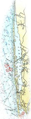
Englewood, Florida
(Lemon Bay -- Placida Harbor on Florida's Gulf Coast)

USCG Auxiliary Flotilla 8-7 AOR
Lemon Bay Channel, Federal Aids (43 Aids)
The coordinates of the Lemon Bay Federal markers were recorded with a state-of-the-art differential GPS reporting 14 ft. accuracy. Each position was recorded with the instrument located 6-10 ft. from the structure. Although every effort was made in each instance to minimize error, no guarantees are expressed or given of the position accuracy. The light characteristics were taken from the Light List.
The Alone/Pair column indicates whether the marker stands alone or is paired across the ICW with another marker (A=Alone, P=Pair).
The structural material was observed by a seaman’s eye (S=Steel, W=Wood, C=Concrete).
| Alone/ Pair |
Name | Lat Deg Min N | Long Deg Min W | Char | Ht | Rg | Str. Mat. | Remarks |
| A | DBN 7 | 26° 52.108' | 82° 18.719' | S | Palm Island & Marina Max | |||
| A | DBN 8 | 26° 52.425' | 82° 18.895' | S | Cape Haze Marina, Ships Lantern | |||
| A | DBN 9 | 26°52.614' | 82°19.040' | W | ||||
| A | DBN 9A | 26° 52.832' | 82° 19.177' | Knights Pass, Rum Bay | ||||
| A | DBN 10 | 26° 53.028' | 82° 19.277' | S | ||||
| A | Light 11 | 26° 53.085' | 82° 19.345' | Fl G 4s | 16 | 4 | W | |
| A | DBN 12 | 26° 53.137' | 82° 19.317' | W | ||||
| P | DBN 13 | 26° 53.580' | 82° 19.363' | W | ||||
| P | Light 14 | 26° 53.650' | 82° 19.339' | Fl R 4s | 16 | 3 | S | |
| A | DBN 15 | 26° 53.726' | 82° 19.427' | W | ||||
| A | DBN 16 | 26° 53.952' | 82° 19.575' | W | ||||
| A | DBN 17 | 26° 53.952' | 82° 19.703' | W | Daughtrey Landing, Marine Dyn | |||
| A | DBN 17A | 26° 54.328' | 82° 19.892' | W | Fish Tail Marina, to Stump Pass | |||
| A | DBN 18 | 26° 54.567' | 82° 20.035' | W | ||||
| A | DBN 19 | 26° 54.695' | 82° 20.152' | W | In line between Lights 14-19A | |||
| P | Light 19A | 26° 54.873' | 82° 20.299' | Fl G 4s | 16 | 4 | W | |
| P | DBN 20 | 26° 54.880' | 82° 20.270' | W | ||||
| P | DBN 21 | 26° 55.230' | 82° 20.569' | W | ||||
| P | DBN 20A | 26° 54.694' | 82° 20.152' | W | ||||
| A | DBN 21A | 26° 55.648' | 82° 20.886' | S | Rocky Creek Marina | |||
| A | Light 22 | 26° 55.839' | 82° 21.004' | Fl R 4s | 16 | 3 | W | Gottfried Creek |
| Tom | Adams | 26° 56.064' | 82° 21.181' | C | Tom Adams Bridge | |||
| A | Light 24 | 26° 56.406' | 82° 21.421' | Fl R 6s | 16 | 3 | W | |
| A | DBN 25 | 26° 56.706' | 82° 21.672' | W | Bayview, Travis BW | |||
| A | DBN 26 | 26° 57.042' | 82° 21.890' | W | ||||
| P | Light 27 | 26° 57.360' | 82° 22.156' | Fl G 4s | 16 | 4 | S | |
| P | DBN 28 | 26° 57.372' | 82° 22.156' | W | Indian Mounds | |||
| P | DBN 28A | 26° 57.698' | 82° 22.370' | W | ||||
| P | DBN 29 | 26° 57.693' | 82° 22.395' | W | ||||
| A | Light 28B | 26° 57.693' | 82° 22.546' | QR | 16 | 3 | S | |
| A | DBN 30 | 26° 58.029' | 82° 22.623' | C | Royal Palm Marina | |||
| A | DBN 31 | 26° 58.425' | 82° 22.939' | S | ||||
| P | Light 32 | 26° 58.690' | 82° 22.939' | Fl R 4s | 16 | 3 | W | |
| P | DBN 33 | 26° 58.662' | 82° 23.113' | W | ||||
| A | DBN 35 | 26° 58.919' | 82° 23.362' | W | ||||
| P | DBN 36 | 26° 59.175' | 82° 23.572' | C | Lemon Bay | |||
| P | Light 37 | 26° 59.174' | 82° 23.607' | Fl G 4s | 16 | 4 | W | Northbound:dim light |
| P | DBN 37A | 26° 59.489' | 82° 23.841' | W | ||||
| P | DBN 38 | 26° 59.507' | 82° 23.821' | W | Forked Creek | |||
| P | Light 39 | 26° 59.861' | 82° 24.114' | Fl G 4s | 16 | 4 | W | |
| P | DBN 40 | 26° 59.871' | 82° 24.091' | W | ||||
| A | DBN 41 | 27° 00.160' | 82° 24.279' | W | ||||
| P | Light 42 | 27° 00.467' | 82° 24.418' | Fl R 4s | 16 | 3 | S | |
| P | DBN 43 | 27° 00.457' | 82° 24.443' | W | ||||
| Manasota | 27° 00.697' | 82° 24.603' | C | Manasota Bridge |